


Latest News
| Technical Advisory Committee for Blue Nile Water Institute of Bahir Dar University has been Established We are pleased to extend our warmest congratulations and welcome you as a valued member of the Technical Advisory Committee for Blue Nile Water... Read More Sat 03 Feb 2024 | Technical Advisory Committee for Blue Nile Water Institute of Bahir Dar University has been established We are pleased to extend our warmest congratulations and welcome you as a valued member of the Technical Advisory Committee for Blue Nile Water... Read More Sat 03 Feb 2024 |
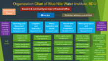 BNWI has been re-organized recently.
Based on a recent decision of the BDU management, the Blue Nile Water Insititute has been re-organized into 5 research units and a unit head or a... Read More
Fri 21 May 2021
BNWI has been re-organized recently.
Based on a recent decision of the BDU management, the Blue Nile Water Insititute has been re-organized into 5 research units and a unit head or a... Read More
Fri 21 May 2021 |
">
Technical Advisory Committee for Blue Nile Water Institute of Bahir Dar University has been Established